2013
Welcoming 2013: Olympic National Park: Rialto Beach, Hole in the Wall, and Points North, December 30, 2012 - January 1, 2013
Foreseeing an opening in my schedule and a break in the weather, I sensed the wilderness trails beckoning. Tim (Nivaun) was game for an opportunity to stretch his legs and do some research for his trail guide to the Olympics.
 |
| Hole in the Wall, ocean, and sea stacks in morning light. Photo by Barking Sasquatch. |
Next day (Monday), we started from camp about an hour before low tide and hiked north until the incoming tide blocked us south of the first point on this trail marked "Caution - Never Round" on the Green Trails Map, at the beach located across from Sandy Island. We waited for the tide to turn before heading back south. We decided to camp in the same spot as the first night, to coordinate the next day's exit hike with the low tide.
 |
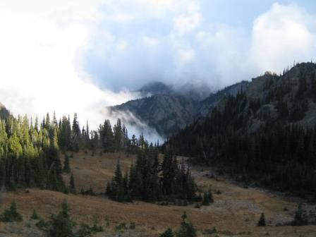
| West end of Lake Crescent with clouds gracing the valley beyond. Photo by Barking Sasquatch. |
 |
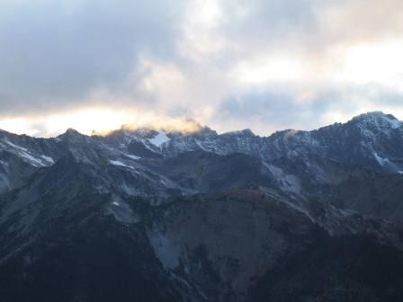
| Mt. Storm King had a dusting of snow by New Year's Day. Photo by Barking Sasquatch. |
 |
| Islands and tidal rocks with pools. Photo by Barking Sasquatch. |


 |
| Elements of the beach: sea grass, tide pool, kelp, wood, and rocks. Photo by Barking Sasquatch. |
 |
| Driftwood-and-rock natural art. Photo by Barking Sasquatch. |
 |
| Ocean-carved rock sculpture. Photo by Barking Sasquatch. |

Wildlife
We encountered bald eagles, crabs, and an otter, all on beaches north of Chilean Memorial.
People
On our hike in Sunday night, we passed two groups of campers between Ellen Creek and Hole in the Wall. On Monday's day hike, we met Granola Girl, Kelsey, Wes, and Jason from Seattle, who were also hiking north. On our exit hike New Year's Day, we encountered beachcombers near the Rialto Beach trailhead.
Trail Conditions
A log across Ellen Creek makes this crossing fairly easy, although a cold morning made the log icy and challenging. Other trip reports have noted the difficult terrain you'll find. Large rocks and boulders covered in red slime make footing difficult and progress slow especially the Chilean Memorial cove and points north. Rounding Cape Johnson is particularly time-consuming.
Camping
There are several camp sites between Ellen Creek and Hole in the Wall, and several more along the beach beyond Hole in the Wall but before you round the point leading to Chilean Memorial cove. It appears that the camp sites near the marker at Chilean Memorial have become overgrown with salmon berry.
~~~~~~~~~~~~~~~~~~~~~~~~~~~~~~~~~~~~~~~~~~~~~~~~~~~~~~~~
2012
Olympic National Forest: Upper Big Quilcene, Marmot Pass, Trail #833, November 7-8, 2012
A break in the rain provided the perfect opportunity for an overnight escape for Tim and our dogs. We camped on the ridge south of Marmot Pass. Not surprisingly, we didn't see another soul.
 |
| Unnamed peak across the Quilcene River Valley from the trail. Photo by Barking Sasquatch. |
The only wildlife we saw was on the drive out of the mountains: a gorgeous owl sitting in a tree near the intersection of the Lower Quilcene trail with the forest road. Snow fell on us overnight, but not enough to make a day hike summit of Buckhorn treacherous or difficult.Trail conditions were as follows:
- Between the trailhead at FR 2750 and Shelter Rock (see bullet below): no snow.
- Between the camp sites (called "Shelter Rock Camp"?) at about 3.0 miles (just past the "Stoves only" sign at 3,500 feet elev.) and Marmot Pass: intermittent snow on the trail less than 1/2 inch deep.
- Marmot Pass: Temp. below 32 degrees. Snow accumulation of less than 1/2 inch. The gravel in the trail provided ample traction to hike in just hiking boots, without traction aids such as microspikes.


 |
| Rime ice at Camp Mystery on Wednesday, before the snow fell. Photo by Barking Sasquatch. |

 |
| View of the peaks beyond the Dungeness River Valley. Photo by Barking Sasquatch. |
 |
| Meadow below Marmot Pass, before snow. Photo by Barking Sasquatch. |


 |
| Temperature at the pass Thursday morning Nov. 8 at about dawn: 18 degrees Fahrenheit. To keep my drinking water from freezing overnight, I used my Platypus water bladder as a pillow and stashed the rest of my water in the bottom of my bag. Water in my Katadyn base camp filter bag sitting in the corner of my tent froze partially. |


 |
| Sun-up, Nov. 8. Photo by Barking Sasquatch. |
 |
| Clouds added dramatic effect to the scenery. Photos by Barking Sasquatch. |


I felt like we put to rest Marmot Pass and the surrounding ridges and mountains for the winter, wrapped in a quilt of clouds and "tucked in" under a light blanket of snow.
Sleep well, Buckhorn Wilderness. Until next spring.


 |
| Hike back down Buckhorn in snowfall. Photo by Barking Sasquatch. |
 |
| Meadow below Marmot Pass after the snowfall. Photo by Barking Sasquatch. |
 |
| Above and below: skiff of snow at Camp Mystery. Photo by Barking Sasquatch. |
 |

 |
| View down the Quilcene River Valley with the Cascade Mountains on the horizon. Photo by Barking Sasquatch. |

 |
| Tia sporting her Ruffwear dog pack and her own bed roll. |
Gear recommendation: Ruffwear dog pack ("Approach" model). My Border Collie wears a medium. It stays on well and doesn't cause raw spots any place on her body or legs. She can carry her own dog food for a 3-day trip or dog food and water on a shorter trip. In this picture, she's carrying her own bed roll, lashed to the top of the Ruffwear pack.

 |
| Mount Constance made an appearance (taken from a turnout off the Forest Service Road). Photo by Barking Sasquatch. |
Sleep well, Buckhorn Wilderness. Until next spring.
~~~~~~~~~~~~~~~~~~~~~~~~~~~~~~~~~~~~~~~~~~~~~~~~~~~~~~~~
Olympic National Park: Flapjack Lakes, August 6-7, 2012
The hike to Flapjack Lakes was another one on my wish list. I took Denise for a one-night stay along the banks of these crystal clear subalpine lakes. Highlights included watching fish rise and enjoying the rosy red glow of sunset reflected on the jagged peaks of Mt. Lincoln and Mt. Cruiser (see pictures).We got a late start due to some Sunday obligations, so we planned to spend our first night at the Staircase car campground.
 |
| Campsite in view of upper Flapjack Lake, Mt. Lincoln, and Mt. Cruiser, Photo by Barking Sasquatch. |
We got a good start Monday morning on the 8-mile trek to Flapjack Lakes. Five hours later, we arrived and set up camp at the upper lake. Including our site, there were only three campsites in use all around the lakes. We really relished the peace and quiet.

 |
| This cool burl of wood sits at the upper end of the bridge over Madeline Creek. Photos by Barking Sasquatch. |

 |
| View from upper flapjack lake toward the lower lake to the west. There is a strip of land between the lakes, in the center of the picture. Photo by Barking Sasquatch. |
 |
| Cool "fork tree" between the lakes. Photo by Barking Sasquatch. |
 |
| Mount Lincoln and Mount Cruiser reflected in upper Flapjack lake. Photo by Barking Sasquatch. |
 |
| Rugged peaks above Flapjack Lake glow pink with reflected evening sunset light. Photos by Barking Sasquatch. |

 |
| Towering giants along the trail to Flapjack Lakes. Photo by Barking Sasquatch. |
A work obligation forced us to return on Tuesday. If we had been able to stay Tuesday night, we would have had time to day-hike up to Gladys Divide, which I understand provides outstanding scenery. I've also heard that Black and White lakes are stellar sights to see. We'll have to take these side trips during a future visit.
Trail Conditions
The trails are in excellent condition. In just a couple spots, we crossed a little water and mud on the trail. Just past the split where you can either head to black and white lakes or Flapjack, there are three tree rootballs to traverse (difficult) and two blowdowns (easy).
People
Two other groups of campers were at Flapjack Lakes. When we stopped for lunch at the junction of the Skokomish Trail and Flapjack Lakes trail, we saw quite a few people continuing up, or coming down, the Skokomish Trail with backpacks. On both Monday and Tuesday, we also saw quite a few people day hiking the section between the Staircase Ranger station and the above-mentioned junction.
Gear
This trip underscored our delight with our Six Moons Designs Lunar Duo. It's easy to pitch, light to carry, and as roomy as a suite at the local Marriott. OK, almost that roomy. Seriously, I'm 6'4" and I can stretch out with plenty of room left at my head and feet for clothes, gear, or whatever, and the vestibule offers ample space for my boots and pack. The light weight of this tent is part of the reason I was able to keep my pack weight at only 18 pounds for this trip (entry hike weight).
Bugs
As you might expect, mosquitoes swarmed in search of blood in the morning and evening. We also experienced our share of flies this trip.
~~~~~~~~~~~~~~~~~~~~~~~~~~~~~~~~~~~~~~~~~~~~~~~~~~~~~~~~
Olympic National Park: High Divide and Seven Lakes Basin, July 27-29, 2012
I had never hiked the High Divide / Seven Lakes Basin before, and Ian hadn't been there in ten years, so it seemed like a good choice for our summer challenge hike. We did the approximately 18-mile loop counterclockwise starting from the Sol Duc parking area Friday around 1:00 p.m., spending Friday night at Lunch Lake and Saturday night at a designated camp site along the High Divide trail not far from Bogachiel Peak. We hiked out via Heart Lake and along the Sol Duc River Sunday afternoon. Enjoy the pictures and the story of our adventure! |
| We encountered this fella, a black-tail deer, when we rounded a corner near the potholes above Deer Lake. He was busy browsing, up to his ears in heather, so we backed away until he was ready to move on. Photo by Barking Sasquatch. |
 |
| This is one of several "pothole" lakes above Deer Lake. Photo by Barking Sasquatch. |
 |
| Wildflowers abound in this brief season between snowmelt and snowfall. This is an example of the wide variety blooming now. We saw this display along the Seven Lakes Basin / High Divide trail within a mile of the Lunch Lake access trail. Photo by Barking Sasquatch. |
 |
| Melt-out is still underway at Lunch Lake, with much of the surface still covered with snow/ice. There is still a considerable amount of snow covering the access trail. By contrast, Clear Lake, just below Lunch Lake, is completely melted out. Photo by Barking Sasquatch. |
 |
| This small tarn above Lunch Lake between camp sites 9 and 11 shows the conditions at Lunch Lake. Considerable snow remains, but some campsites are melted out. The surface of the tarn re-froze overnight and had a 1/4-inch layer of ice by morning. Photo by Barking Sasquatch. |
 |
| View of the lakes basin from the ridge near Bogachiel Peak. If you look closely, you can see the deep blue hue of the meltwater in some of the lakes. Photo by Barking Sasquatch. |
 |
| This picture shows the conditions of the lakes in the upper basin. Photo by Barking Sasquatch. |
 |
| This picture shows conditions typical along the High Divide east of Bogachiel Peak. In places the trail is clear and dry, and in other spots, considerable snow remains. Photo by Barking Sasquatch. |
 |
| On Saturday, the clouds added a dramatic interplay with the rugged mountains. By mid-afternoon, thick cloud cover moved in all around us, creating foggy, eerie white-out conditions along the High Divide trail and obstructing views of the Hoh River valley, Mt. Olympus, and the Olympic range. Photo by Barking Sasquatch. |
 |
| White-out conditions blocked our view of far-off grand vistas but made nearby attractions such as this Bear Grass more appealing. Photo by Barking Sasquatch. |
 |
| Unsure whether Sunday (our last day on the trail) would bring us more clouds and white-out conditions, we cooked and ate dinner near our campsite in a spot that gave us the best possible vistas. I took this picture of Mt. Olympus from that spot, when the clouds parted for a few seconds. Photo by Barking Sasquatch. |
Sunday morning dawned completely clear. We decided to take our breakfast to the top of Bogachiel Peak to witness the broadest possible expanse of views across the Olympic Range to the south and east, as well as the early morning sunshine on the snow-filled lakes basin below. We enjoyed the natural wonder, and our coffee and breakfast, in complete solitude and quiet.
 |
| First light on Mount Olympus, July 29, 2012. Photo by Barking Sasquatch. |
 |
| Olympus and her neighbors surrounded by a sea of clouds filling the Hoh River valley. Photos by Barking Sasquatch. |

 |
| Mt. Olympus and the range from Bogachiel Peak. Photo by Barking Sasquatch. |
 |
| Mt. Olympus and Lupine from the ridge near Bogachiel Peak. Photo by Barking Sasquatch. |
 |
| Two adult goats and two kids on Bogachiel Peak Photos by Barking Sasquatch. |

Olympic Mountain Goats can become habituated to human presence and can be aggressive, so we kept our distance, did not approach, and left the area as soon as we could access the trail back down the peak.
 |
| This is the first time I have seen this color Paintbrush. It was on the ridge near Bogachiel Peak. I believe the mountains in the background include Mt. Carrie and part of the Bailey Range. Photo by Barking Sasquatch. |
 |
Avalanche Lilies line both sides of the High Divide trail above Heart Lake. Photos by Barking Sasquatch.  |
 |
| Unobstructed view of Mt. Olympus seen from a snow-covered spot on the High Divide trail. Photo by Barking Sasquatch. |
 |
| Nice view to the east from the High Divide trail, into the heart of the Olympics and the Bailey Range. Photo by Barking Sasquatch. |
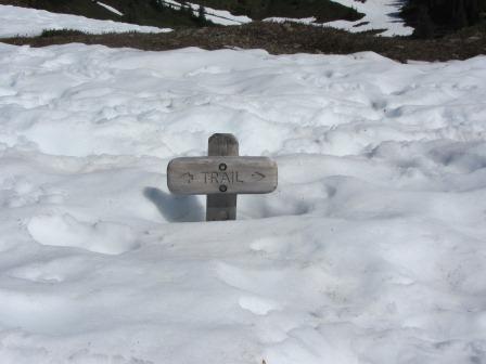 |
| Trail sign near Heart Lake. Photo by Barking Sasquatch. |
 |
| Heart Lake looking rather half-hearted thanks to snowpack. Photo by Barking Sasquatch. |
- Sol Duc parking area to the Potholes above Deer Lake: good trail conditions, and snow-free. Beyond Sol Duc Falls, the tread is uneven and rocky in many places.
- Potholes above Deer Lake to Lunch Lake access trail: intermittent snow patches, most of them easy to cross with trekking poles and hiking boots. Helpful to have spikes or crampons and ice axe as a precaution.
- Access to Lunch Lake: considerable snow remains. Helpful to have spikes or crampons and ice axe as a precaution.
- High Divide from Bogachiel Peak to Heart Lake: quite a few snow patches, most of them easy to cross.
- Below Heart Lake: we encountered a couple patches of snow that proved somewhat challenging to cross, simply because of their location or the fact that a snow bridge had formed over a stream.
As far as we could tell, we were the only campers at Lunch Lake on Friday night. Throughout Saturday, we encountered only three people all day long. On Sunday, we encountered nobody on Bogachiel Peak, but ran across several parties of hikers on the High Divide trail.
Gear
This was the first time I used my Kahtoola microspikes for any great distance. They work great: easy on and easy off, and not too heavy to carry. I can roll them up and store them in a small pouch that's the same size as the one I use for my small point-and-shoot camera.
Bugs
A few no-see-ums pestered us, a few skeeters tried to nail us, and a couple flies alighted on our skin for a second or so, but all-in-all, not a bad trip, insect-wise.
~~~~~~~~~~~~~~~~~~~~~~~~~~~~~~~~~~~~~~~~~~~~~~~~~~~~~~~~
Olympic National Park: Dosewallips River from the Washout to Dosewallips Campground, July 21-22, 2012
I wanted to get my family out for their first overnighter for the season, and after my first experience in early June, the Dosewallips seemed like just the thing.There was some excitement at the trailhead when we arrived: an ambulance from Brinnon Fire & Rescue. Then some young men running along the trail carrying a length of rope. We hoped we wouldn't see blood or rescue helicopters next. Thankfully, the shutter that came past, supported by four people and one wheel, carried only rescue gear. I think there had been a rescue drill that afternoon.
 |
| It isn't flowing as high as it was in June, but the beauty of the Dosewallips doesn't disappoint. Photo by Barking Sasquatch. |
We had a delightful time reconnecting as a family and enjoying physical exertion and silliness together out in the fantastic natural surroundings that we enjoy here in western Washington.
 |
| A grouse and her young chick (not visible) hung around for a photo opp as we walked by on the very steep incline next to the falls pictured above. Photo by Barking Sasquatch. |
 |
| Some day this spindly little Madrone will tower over the Dosewallips trail. Photo by Barking Sasquatch. |
 |
| The walk provides some great vistas of both river and forest. |

In camp, we found plenty to do: we picked wild strawberries in season, and we created a game out of walking along the many blowdowns in the east end of the campground, trying to avoid touching the grass by hopping from one log to another. We skipped stones in the river and played cards on the picnic table (Furniture! What a luxury when you're backpacking!). Of course, lying on the riverbed and listening to the Dosewallips flow by was a relaxing highlight.
 |
| This picture is typical of the Dosewallips Campground: Tame deer wandering through camp, and the vault toilet with its fancy tarp door. We weren't camped that close to the toilet; telephoto makes it look closer than it really is. :-) |
 |
| They're tiny, but they pack a burst of flavor. In about ten minutes, my wife and two daughters picked enough strawberries for everyone to have a generous portion on top of our breakfast oatmeal. Photo by Barking Sasquatch. |
 |
| Martha Stewart can't top this camp cooking: Oats (hand-rolled from the whole oat groat just before we left home) simmered in mountain water, topped with toasted almonds and wild strawberries: Breakfast of Champion Hikers! |
 |
| Sisters leading the way. That's what I like to see. Photo by Barking Sasquatch. |
There were about three other groups camped at Dosewallips Campground. We saw several people on the forest service road-turned-trail: some hiking and some riding mountain bikes. We saw many more at Elkhorn Campground, where we stopped for lunch on Sunday.
Bugs
We needed bug repellent to fend off the skeeters.
Critters
A tame deer wandered through camp Saturday evening and again Sunday morning. Grouse along the trail posed for pictures.
Gear
As the girls grow, we need to remember to adjust their backpacks to fit them! Generally, all our gear worked well for us. I hadn't set up our Marmot Aura two-person tent in awhile, so I wondered if I'd remember how. Luckily, my wife got it started while I helped the girls set up the Six Moons Designs Lunar Duo. That Marmot Aura is one rock-solid, reliable tent, and cozy and roomy, too.
~~~~~~~~~~~~~~~~~~~~~~~~~~~~~~~~~~~~~~~~~~~~~~~~~~~~~~~~
Olympic National Forest: Tubal-Cain Trail #840, Tull Canyon Trail #847, and Gold Creek Trail #830 June 16-17, 2012
Father's Day meant my choice of activity, and this year it was camping overnight in the shelter at the Tubal-Cain trailhead and two day hikes: one along the Tubal-Cain mine trail and up Tull Canyon, and the other on the Gold Creek trail. My daughters hadn't seen the crashed bomber in Tull Canyon. The attraction of this relic along with a couple on-trail diversions helped our girls avoid boredom and complaining along the miles. |
| Home sweet shelter without the tent. You can carry your gear without a pack from the parking area to the shelter, a distance of just about 75 yards. Photo by Barking Sasquatch. |
 |
| The Gold Creek trailhead shares a parking area with the Tubal-Cain mine trail. You can access the Gold Creek trail across the forest service road from the entrance to the Tubal Cain parking area. |
 |
| The Gold Creek trail is a sweet, well-maintained little trail that shows hardly any wear despite being used by hikers, mountain bikers, and horse riders alike. This is a view from the Gold Creek trail. Photo by Barking Sasquatch. |
Trail characteristics
The Gold Creek trail bears a gentle descent for the first two miles from the trailhead at Tubal-Cain.
The trail to Tubal Cain mine camp is a gentle and gradual ascent. The trail was snow-free all the way to the Tubal Cain camp.
The trail up Tull Canyon is quite steep. In the spring and early summer, one creek crossing can be quite difficult. We got our feet wet from the splash of water falling onto the rocks on which we stepped. It is helpful to have trekking poles or a walking stick for this crossing.
Finding Tull Canyon
It can be easy to miss the start of the Tull Canyon trail because the sign is posted fairly high on a tree. When you are nearing the start of the Tull Canyon trail, you will pass through forest that has very little green underbrush. There are a few very large trees and many, many fallen tiny trees scattered about the forest floor. Start looking up and to your left, and you will see a rock wall with quite a bit of moss on it. You may notice one of the mine entrances cut into the rock, and then the sign for the Tull Canyon trail. We walked into the mine opening. It only goes about 20 feet back.
You start noticing pieces of the plane on the forest floor after you cross the creek a second time, a crossing that is easier because there are two logs to walk on.
 |
| These pieces of the crashed plane are quite prominent in the clear area near the pond. Photo by Barking Sasquatch. |
 |
| Another relic, this one from the days of active mining operations - remnants of a building in Tull Canyon. Photo by Barking Sasquatch. |
The crashed plane provides a fascinating and unusual attraction. But the natural surroundings in Tull Canyon are the real reward. They wrap around you, inviting you to stay awhile. The ridges and spires tower above, and a gentle creek trickles into a reflecting pond at your feet.
 |
| The ridge east of Tull Canyon. I'm told that Silver Lakes are on the other side. I'd like to make the off-trail traverse over it someday. Photo by Barking Sasquatch. |
Because we camped in the shelter and did day hikes, we didn't bring all of our backpacking gear. But one essential piece was our Katadyn Base Camp water micro filter. It's my choice for backcountry travel because it uses gravity rather than human-powered pumping action. I admit: I can be lazy. Whether I'm with one friend or my whole family, it's handy to have a source of water in camp. It's uncomplicated, requires very little maintenance, and we've never had a problem with it. Empty, it rolls up and packs nicely.
~~~~~~~~~~~~~~~~~~~~~~~~~~~~~~~~~~~~~~~~~~~~~~~~~~~~~~~~
Olympic National Park, West Fork Dosewallips River, Trail #101 June 1-3, 2012
Two nights in the Olympics at Big Timber camp along the Dosewallips River, with a day hike just past Diamond Meadows along the Dosewallips.Matthew and I went out for a leg-stretcher and really ended up decompressing and completely relaxing. There is just something about the constant rush of a river that will wash away life's worries and turmoils. Matthew got the opportunity to try out some new gear including a Big Agnes insulated air sleeping pad and an Osprey pack.
 |
| The mighty Dosewallips falls through a slot not far below the Dosewallips Campground. |
Black bear sighting! On Saturday afternoon, we saw a black bear directly across from the bear wire at Big Timber, uphill from the trail. It slowly browsed around the hillside and disappeared.
On our Sunday exit hike, we encountered a group of four deer browsing along the former forest service road. I don't recall ever seeing four deer together in a group.
- Trail conditions parking area to Big Timber camp: excellent
- Trail conditions Big Timber to Diamond Meadows: intermittent snow on trail starting about 1.5 miles past Big Timber. It was fairly compact and easy to hike on without traction or snowshoes.
- Trail conditions Diamond Meadows and beyond: we encountered solid snow just past Diamond Meadows, and it became difficult to follow the trail. We turned back at this point.
 |
| Cool snowmelt sculpture at Diamond Meadows; photo by Barking Sasquatch. |
 |
| Snow bridge at the log crossing at Diamond Meadows; photo by Barking Sasquatch. |
On Friday, we saw one large group camped at Dose Forks. On Sunday morning, we could see two sites occupied at Dose Forks.
Beyond Dose Forks, we did not encounter a single person the entire weekend.
 |
| Laying around staring up at the swaying conifers can be incredibly relaxing; photo by Barking Sasquatch. |
 |
| This beats electronic entertainment any day; photo by Barking Sasquatch. |
 |
| Yep, the native rhodies are blooming! Photo by Barking Sasquatch. |
 |
| A crazy-beautiful tributary we crossed; photo by Barking Sasquatch. |
 |
| The mighty Dosewallips roars down the mountain at the bridge crossing at Dose Forks; photo by Barking Sasquatch. |
If you stayed home because the forecast called for crummy weather, you missed out (but we thank you for allowing us our solitude), because the weekend was incredibly nice, weather-wise. Temps the entire time were quite mild, and we felt only a very few sprinkles of precip that didn't last long enough to wet our jacket sleeves, and then dissipated.
Good gear choices for this trip:
--Gossamer Gear Gorilla pack. Perfect size and comfortable for carrying 24 pounds (entry hike weight), including food, water, and a couple beers.
--FeatherFire Denatured Alcohol stove from Packafeather (brought water to rolling boil for curry cous-cous with chicken, apricots, sundried tomatoes, and almonds).
Gear I forgot:
I remembered everything this time. whew.
I remembered everything this time. whew.
~~~~~~~~~~~~~~~~~~~~~~~~~~~~~~~~~~~~~~~~~~~~~~~~~~~~~~~~
Olympic National Forest, Upper Dungeness to Boulder Shelter and Marmot Pass, Trail # 833 May 11-13, 2012
 |
Boulder Shelter
|
 |
Basin at Boulder Camp
|
 |
| Buckhorn Mountain from the Ridge South of Marmot Pass |
 |
| Mt. Constance and Beyond from the Ridge South of Marmot Pass
Chilly at night (dog's water froze Friday night), but warm and sunny all day.
Good gear choices for this trip:
--Six Moons Designs Duo (fit nicely inside the Camp Handy Shelter, and dog fit nicely inside the vestibule)
--FeatherFire Denatured Alcohol stove from Packafeather (nice adjustable simmering control for the chicken and mushrooms in tomato sauce over cous-cous dinner, and for simmering morning oats)
--30-degree bag
--Down mid-layer sweater for evening and morning
--MSR Lightning Axis 25's, my second trip with them. The elevator feature was incredibly handy in spots hiking up to Marmot. On sidehills, not so much. On sidehills, I felt more in control in just my leather hiking boots.
Gear I forgot <where was my head?!):
--Tent poles <doh!> (fortunately, the Six Moons Designs Duo pitches with trekking poles, and seemed to work fine without the curved poles that go above the doors.)
--Outdoor Research gaiters (I only missed them coming down from Marmot, when it was warm enough to sink a bit into the snow, and we glissaded. Luckily, I had time before sunset back at base camp to dry out my boots and socks a bit!)
--Kahtoola microspikes (would have been handy for sections of the snow-hike between Boulder and Marmot).
|
Beautiful photos. Thanks for sharing your experiences and gear recommendations.
ReplyDeleteYou're welcome. I have been remiss in posting trip reports since early August and was slow to answer your comment. Sorry! I'm glad you have benefitted from my posts.
Delete